JET STREAM & ITS SIGNIFICANCE
MEANING AND ORIGIN
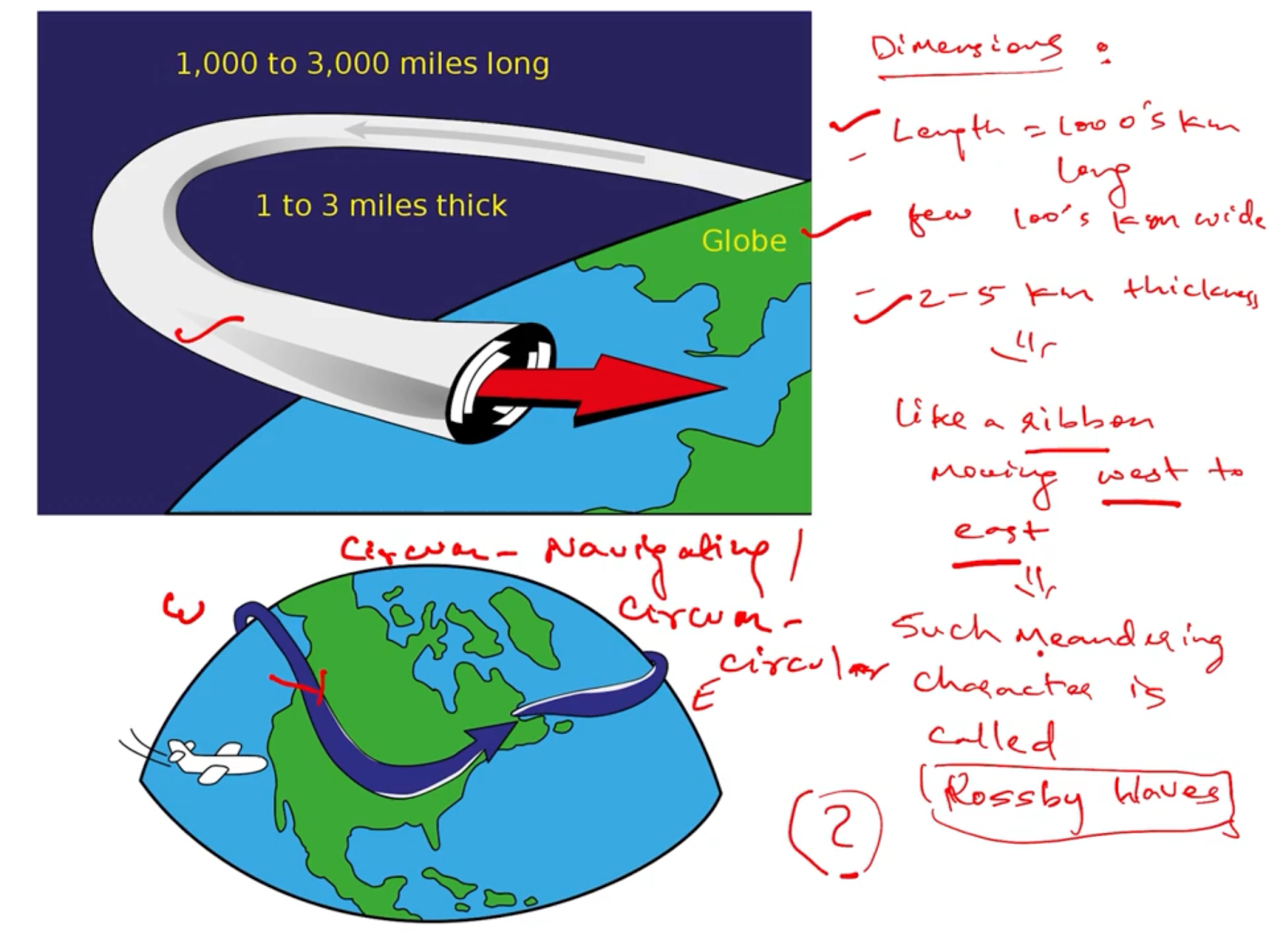
CHARACTERISTICS
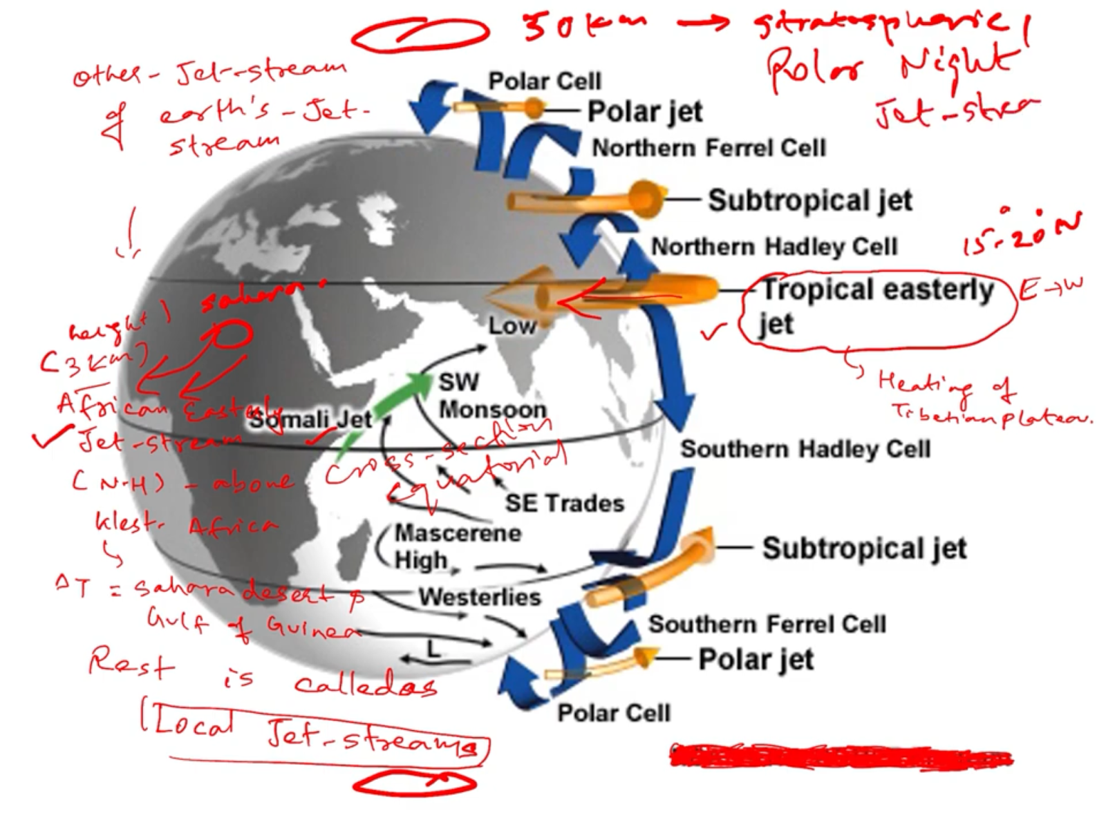
TYPES AND ITS DISTRIBUTION
CAUSE AND MECHANISM
WEATHER ASSOCIATED WITH JET STREAM : CYCLONIC & ANTI-CYCLONIC WEATHER SYSTEM OF MID-LATITUDES & HIGHER LATITUDE
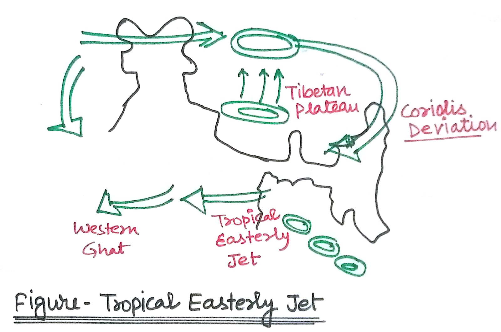
ROLE OF WESTERLY JET STREAM AND TROPICAL EASTERLY JET STREAM TO EXPLAIN THE INDIAN MONSOON MECHANISM & WESTERN DISTURBANCES ?
OZONE DEPLETION RELATION WITH JET STREAM
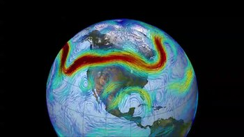
Jet streams are narrow bands of strong wind that blow in the upper atmosphere from west to east(mostly) at the height of 8-15km. They occur where there exist large thermal gradient (temperature difference) . During winters jet streams are stronger as the thermal contrast across the warm and cold air masses or atmospheric cycles intensified.
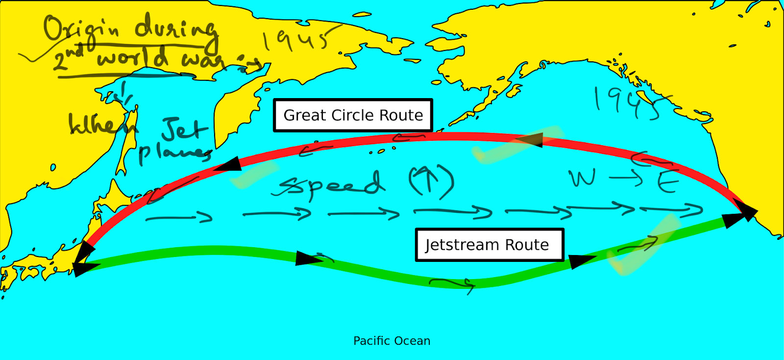
During the world war II , when jet planes moving from japan to USA or return to japan from usa the speed increases and decreases respectively across pacific ocean. Then scientist there is some fast moving wind in the atmosphere eastward called jet stream. Many sources credit real understanding of the nature of jet streams to regular and repeated flight-path traversals during World War II. Flyers consistently noticed westerly tailwinds in excess of 160 km/h (100 mph) in flights, for example, from the US to the UK.[12] Similarly in 1944 a team of American meteorologists in Guam, including Reid Bryson, had enough observations to forecast very high west winds that would slow bombers going to Japan.
CHARACTERISTICS :
Fast blowing upper atmospheric wind at the height of 4-14km (9average height =12km),
Speed = 90-500km/hr ; average speed -120-250km/hr.
Jet stream follows the zig zag path such meandering currents are called ROSSBY WAVES.
They are circumnavigating or circum-circular in nature
Jet streams are geostrophic wind i.e., wind flows parallel to isobars.
Jet stream moves eastward or west to east , mainly permanent tropospheric jet stream at 30degree and 60degree latitude.
Jet stream splits and join again and again due to variation in the ground conditions
Jet stream are shifting with : (A) season --jan & july (B) at coastal area
Shifting of jet streams observed both horizontally and vertically due to GEOSTROPHIC BALANCE( PGF = Cf) & HYDROSTATIC BALANCE respectively(PGF = Gravity).
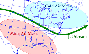
Jet streams are found where two alternate air masses or atmospheric cycles meet; due to temperature contrast across the front in the upper atmosphere these jet streams develop.
Jet stream impact the weather conditions at global, regional and local level.
Jet streams are observed within the troposphere, stratosphere, mesosphere,etc even in other planets' atmospheres too..but we are concerned mainly with tropospheric jet streams only.
Within the troposphere jet stream is found at several height : low levels jet stream (4-8km); mid-level jet stream (12km-15km).
Ribbon appearance characterised by long lengths of 1000’s km , width 100’s km, thickness of 2-4km.
Types and distribution of jet stream :
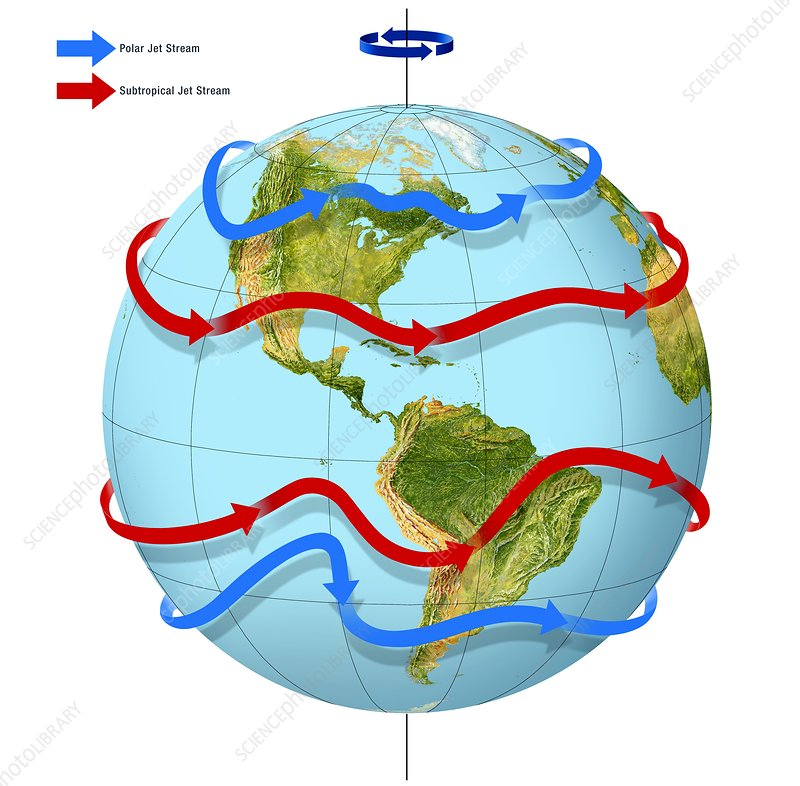
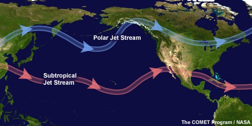
These are two permanent jet stream that moves in both northern and southern hemisphere west to east called as :
Sub tropical westerly jet stream--30 degree latitude
Polar jet stream.
Apart from these two there are many regional and seasonal, and local jet stream is found.
Tropical easterly jet stream (east to west)
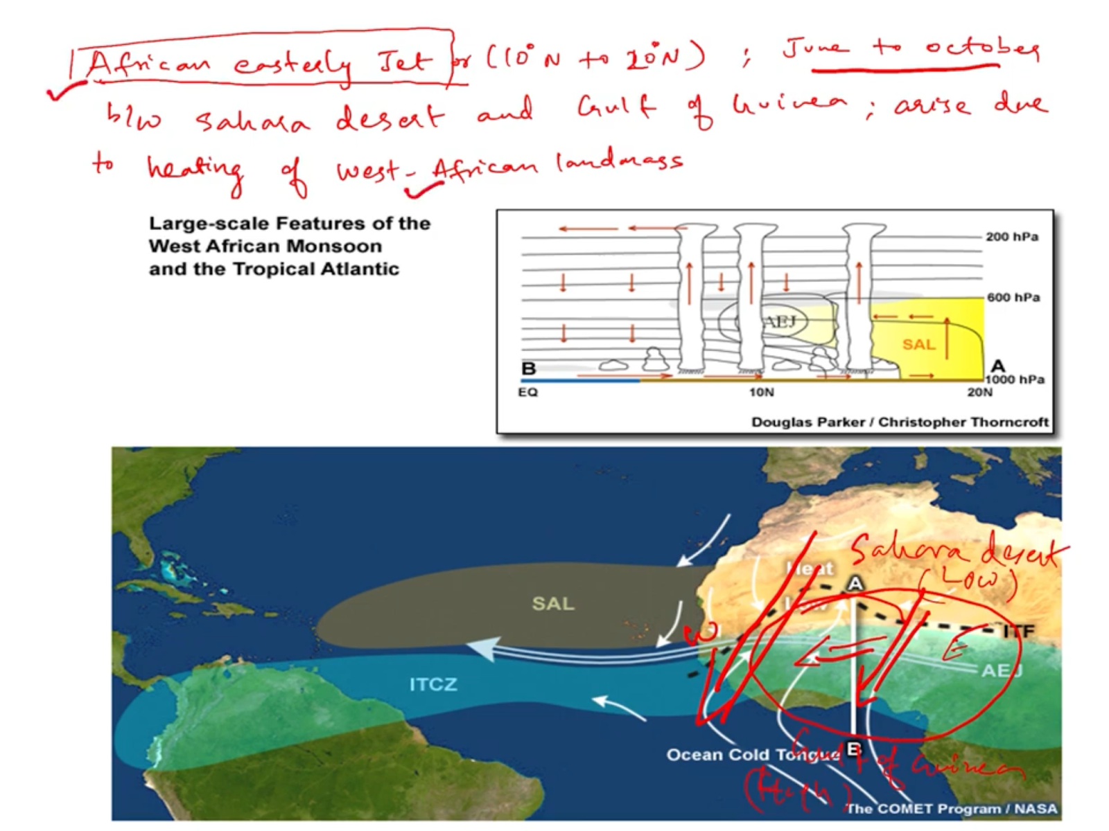
African easterly jet stream(east to west flow) ; 3-5km height
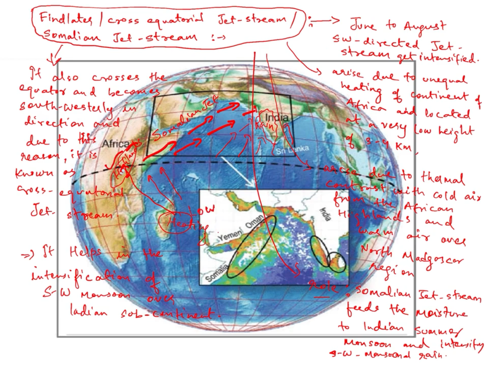
Somalian jet stream or cross-sectional equatorial jet stream(crosses equator moves from Madagascar to Ethiopian highland), 3-5km
Stratospheric polar night jet stream at the height of 40-50km
Others : local jet stream.
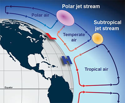
CAUSES : when two alternate air masses/aircycles meets then at boundary jet stream develop because of extreme temperature contrast. At global level there are three atmospheric cells : Hadley cell, Ferrel cell, & Polar cell. Two opposite type of air cycles meets at 30 degree and 60 latitude. Thus forming the permanent jet stream
At 30 degree latitude ,at the height of 12km , hadley cell and ferrel meet and their temperature difference drive the subtropical westerly jet stream.
At 60 degree latitude , at the height of 8km, ferrel cells and polar cells meet and the temperature difference between these cells drives the polar jet stream. Which is more stronger than
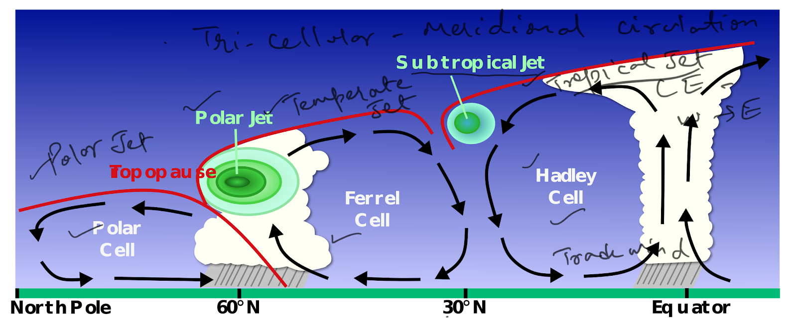
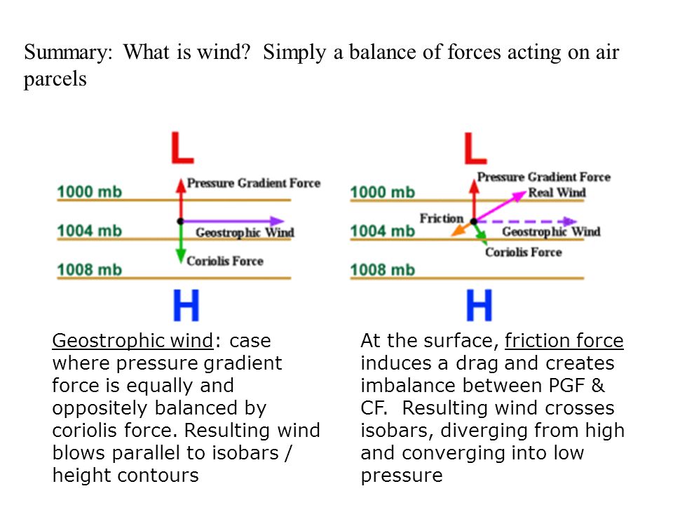
In the upper atmosphere , the pressure gradient is from hot areas to colder area. That means from equator to pole( think opposite of ground condition). So, air moves from high pressure to low pressure area.
Now, wind moving from equator to pole in the upper atmosphere, encounters with the coriolis effect due to rotation of the earth . in the northern hemisphere wind deflects towards the right while in the southern hemisphere towards left. Thus , at a particular height pressure gradient force balance equal and opposite to coriolis force in absence of frictional forces then the resultant wind flows parallel to isobar and becomes GEOSTROPHIC WIND. Thus the permanent jet stream moves eastward.
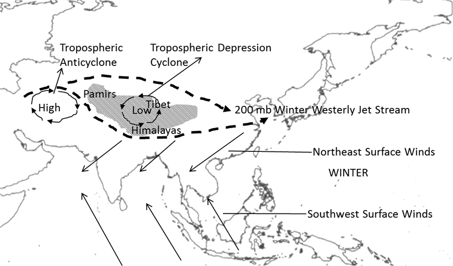
Tropical easterly jet stream produced by heating of Himalayan Tibetan zone in summer and blows east to west.
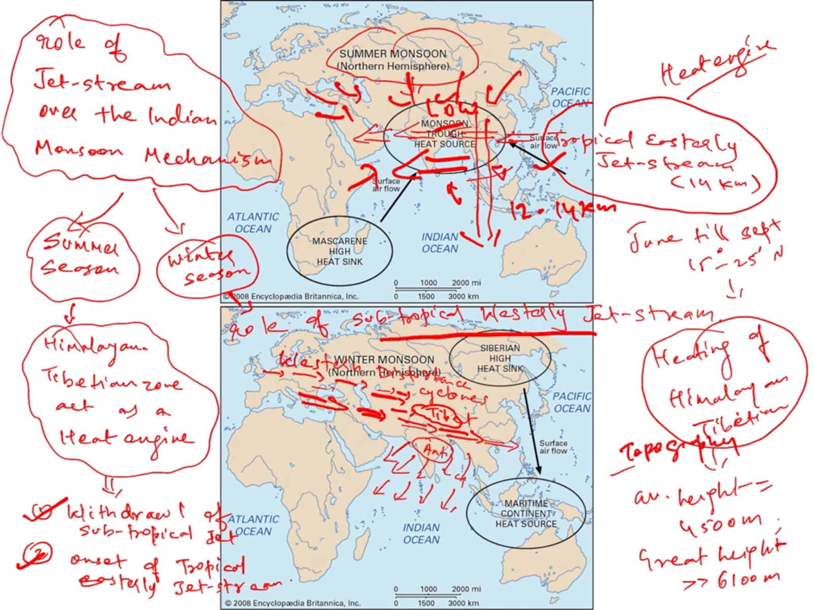
East African jet stream also produce by heating of Saharan desert and it flows east to west to Gulf of Guinea.
Flindlater or Somalian jet stream produced by differential heating between Ethiopian highland and Madagascar.
Conclusion for the formation of jet stream : in upper atmosphere steep pressure gradient is developed when hot and cold air masses meets up . At the front , the fast moving wind develops from hot areas to cold area at height 8-15km and this winds become geostrophic due to rotation of the earth (coriolis force). Thus jet streams flows parallel to isobars.

Significance or role of jet stream :
Question :
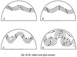
Q : What do you mean by the Index Cycle of a Jet Stream? How does Jetstream influence the surface weather conditions?
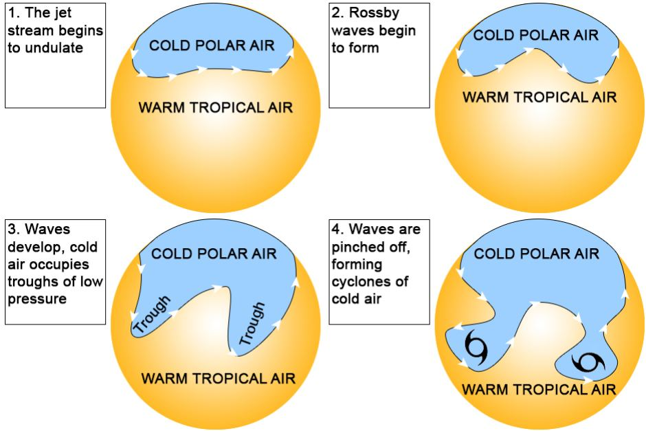
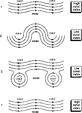
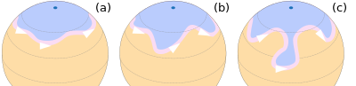
ANS : There are changes in the position of the extent of the jet stream from poles towards the equator. The wavy (meandering) jet stream is called Rossby waves. The period of transformation of straight path of jet stream A wavy or meandering path is called an index cycle which is completed in four successive stages. The figure adjacent shows different stages of the index cycle of jet streams.
In the first stage (Fig a) the jet stream lies quite close to the polar regions and flows from due west to east. In the northern hemisphere, the cold air mass is found to the north of the upper-level westerlies. To the south of the jet lies the mild air of the mid latitudes. The westerlies in this stage have shifted towards higher latitudes where there is a lot of cyclonic activity. Pressure systems
in this stage have got east-west orientation. North-south pressure gradient is relatively steeper. The air mass exchange between the temperate and tropical regions is at its minimum. The first stage thus represents the high zonal index.
In the second stage (Fig b), the amplitude of jet stream waves increases. The whole of the jet moves towards the equator as a result of which there is an inroad of cold polar air southward. The warm air masses from lower latitudes move towards higher latitudes.
In the third stage, the bends in the jet stream become sharper and the amplitude of waves registers a further increase (Fig c). At this stage the tropical air masses moves farther north, and the cold polar air moves farther south. Now, the jet stream is positioned nearer the equator and the exchange of tropical and
polar air masses takes place on a much larger scale. The temperature gradient is
directed from east to west In the last stage of the index cycle, the giant size meander cut off from the mainstream. The result is that an immense pool of cold and dense polar air is isolated in the upper troposphere of the lower latitudes where it is encircled by entirely different air masses. In the upper atmosphere of higher latitudes, the tropical air mass are entrapped by the colder air. This is called the low zonal index of the jet stream. The zonal character of the upper-level westerlies is no longer In existence. They are fragmented into a number of cells.
JET STREAM AND SURFACE WEATHER
Jets streams play a key role in determining the weather because they usually separate colder air and warmer air. Jet streams generally push air masses around, moving weather systems to new areas and even causing them to stall if they have moved too far away.
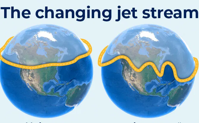
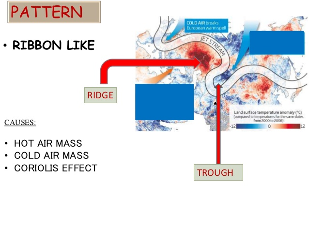
While they are typically used as one of the factors in predicting weather, jet streams don’t generally follow a straight path — the patterns are called peaks and troughs — so they can shift, causing some to point at the poor forecasting skills of meteorologists.
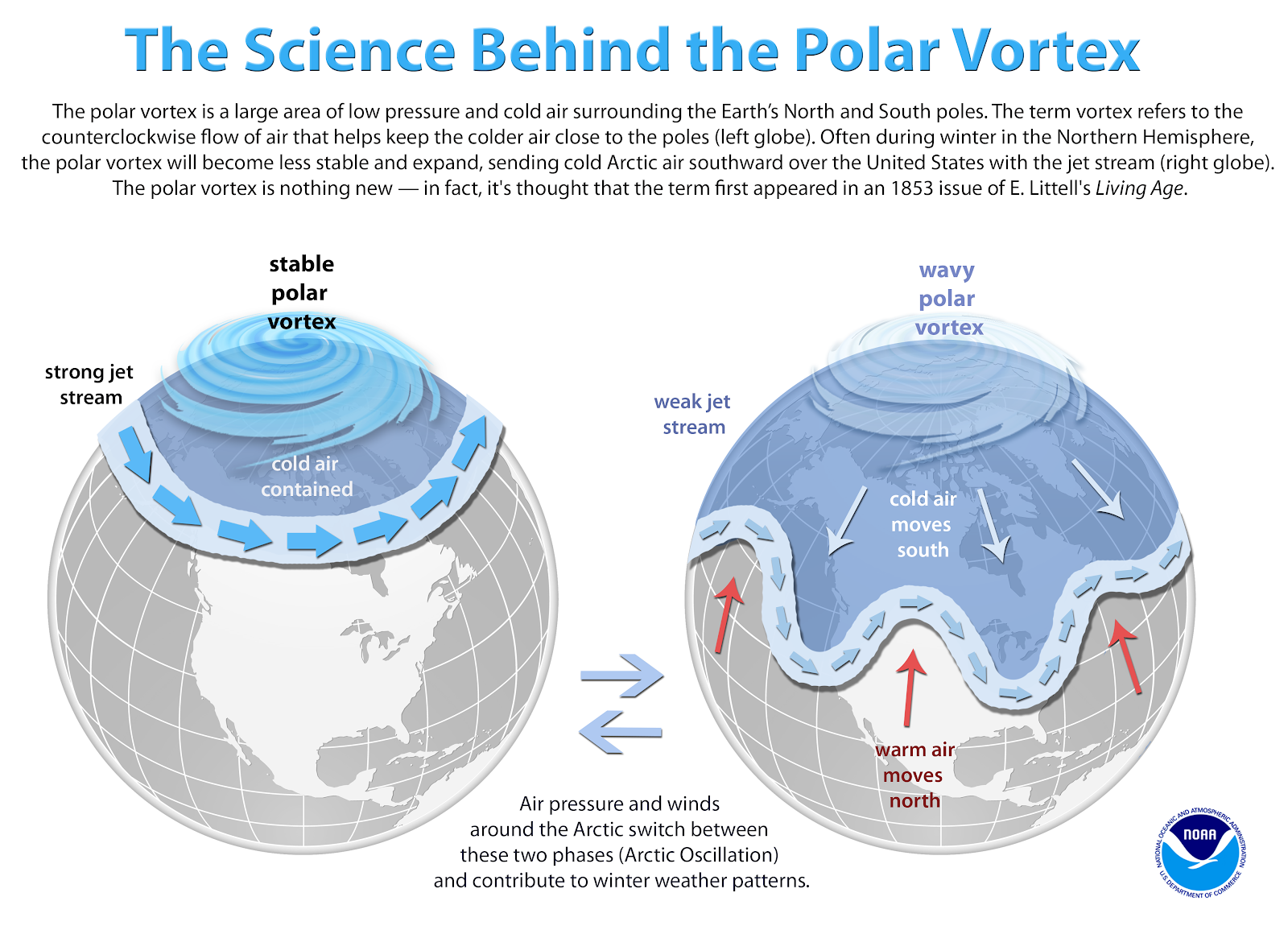
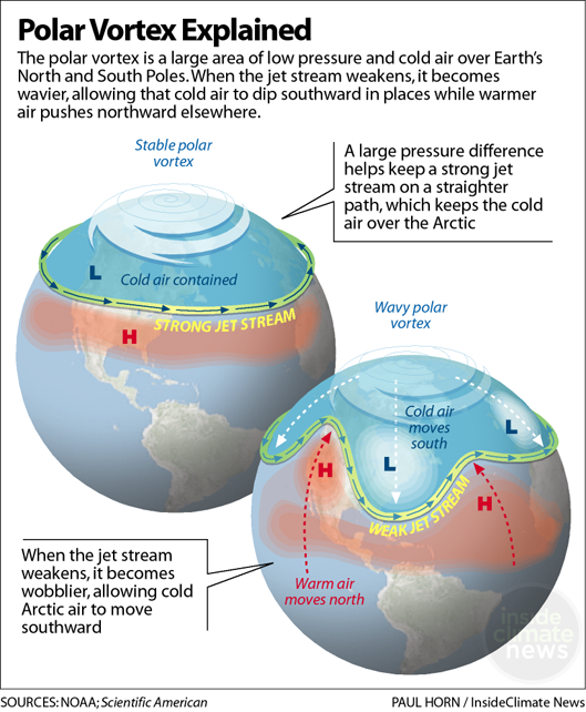
Climatologists say that changes in the jet streams are closely tied to global warming, especially the polar jet streams, because there is a great deal of evidence that the North and South poles are warming faster than the remainder of the planet. When the jets streams are warmer, their ups and downs become more extreme, bringing different types of weather to areas that are not accustomed to climate variations. If the jet stream dips south, for example, it takes the colder air masses with it.
Jet streams also have an impact on air travel and are used to determine flight patterns. An airplane can travel much faster, and save fuel, by getting “sucked up” in the jet stream. That can also cause a bumpy flight, because the jet stream is sometimes unpredictable and can cause sudden movement, even when the weather looks calm and clear.
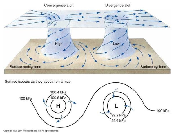
Jetstream is responsible for convergence and divergence of air both at the ground and upper-atmosphere. Thus , forming atmospheric circulation system, cyclonic and anticyclonic condition, dry vs wet weather, cloudy vs clear skies ,etc..
Jetstream with season or other factors may become stronger or weaker thus affecting the polar vortex movement . the colder air of poles is confined around poles due to strong polar vortex, which further maintained the low pressure centre in upper atmosphere(8km height).
The role of jet streams esp., polar jet & subtropical jet affect the mid-latitude, and higher latitude weather conditions more ..can explain why rain or dry condition produces; it shift airmasses ,defines temperature, wind nature and speed.
Jetstream is used by air traffic to determine the flight path and pattern.
Jet stream disperses the air pollutant
Jet stream can explains the ozone hole over arctic and antarctica zones and widens during winters.
Jetstream can explain the monsoons arrival over indian subcontinent
Jet stream can explain the western disturbance phenomena as westerly jet stream and westerlies moves eastward cause rain in northwest india.
Extreme weather condition : hot waves and cold waves events are intensifying with climate change and jetstream.
Jetstream confine the position of atmospheric cells such as hadley cell, ferrel cell, polar cell and corresponding surface winds, and its role on surface weather condition.
Indian summer monsoon rain arrival is declared by withdrawal of subtropical westerly jetstream from india and establishment of tropical easterly jetstream as it creates cyclonic conditions over indian subcontinent. Arabian sea branch of the south west monsoon is stronger due to stronger somalian current.
Indian winter monsoon develop as south of himalays subtropical westerly jet stream develops that maintains the anticyclonic condition over india. Thus developing northeast monsoon.
The jet stream is said to play a very significant role in controlling the behavior of terrestrial atmosphere. But the exact nature of this relationship still remains less understood. Now, it is an established fact that the so-called polar-front jet streams are closely related to the middle-
latitude weather disturbances. The meanders of the more northerly upper-tropospheric jet stream determine the location of the surface polar front.
There are evidences to suggest that the eddies produced in these upper air streams come down to affect the cyclonic weather. The paths followed by the cyclones are also largely controlled by these upper-level high velocity westerlies.
Even the distribution of precipitation by extratropical cyclones is indirectly influenced by the jet streams aloft. Meteorologists agree that areas lying below the jet may have heavy precipitation. Rainfall, snowfall, thunderstorms of varying intensities, tornadoes, cold waves or snow storms are all directly affected by the jet streams aloft.
The jet streams also play an important role in the movement of different air-masses which may produce a prolonged period of drought or flood.
Besides, migration of high and low-pressure cells on the surface of the earth is also directly related to the shifting positions of the jet streams as they move around the earth. For instance, the dynamically produced high pressure cells within the subtropical belts owe their existence to the upper westerlies and the jet stream.
Examples:
o A jet stream band near the North Pole essentially confines the Polar Vortex. When the jetstream near the pole buckles, the Polar Vortex can shift its position farther south and allow frigid air to spill toward mid-latitudes.
o In the autumn, the presence of a strong west to east jet stream over the United States may keep a brewing hurricane from making a northward turn over the Gulf Coast or along the Atlantic Seaboard.
o (Also add examples of Sub-Tropical Westerly Jetstream influencing Indian climate.) Whatever be the cause of the everchanging patterns of the jet, there is hardly any doubt that the jet streams have important repercussions upon the world weather. There is no denying the fact that a clearer understanding of different aspects of the jet streams will help the weather scientists in making a correct appraisal of the surface weather.